
Global Climate Impacts: Wildfire Risk, Support Gaps, and Agricultural Stress
Longer-burning wildfires are raising risks in Canada, aid cuts are increasing vulnerability in Central America, and shifting rainfall is affecting crops and wildlife in Brazil and Peru

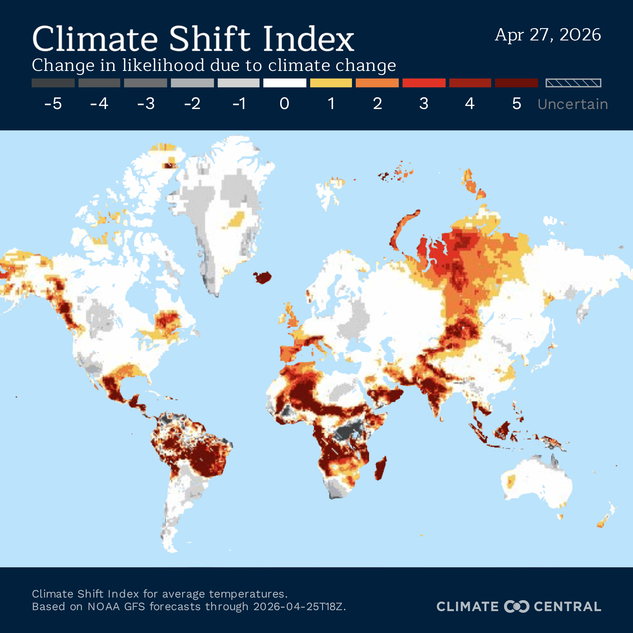
Climate Central’s Climate Shift Index1 (CSI) indicates that temperatures are well above normal across much of the globe this week. In Canada, longer-burning wildfires, rising smoke-related mortality, shifting caribou migrations, and changing winter conditions are affecting both ecosystems and livelihoods. In Brazil and Peru, climate-driven disasters, shifting rainfall patterns, and warming trends are reshaping displacement, biodiversity, and agricultural systems. In Guatemala and Belize, climate vulnerability is intersecting with food insecurity, coastal exposure, and the loss of international support, raising concerns about resilience in already at-risk communities.
While we are focusing on three distinct regions for this week’s post, we want to acknowledge that many of the regions we have covered over the past month continue to experience conditions influenced by human-caused warming—particularly Central and Western Africa and the Middle East. For more on how climate change is impacting these regions, see our posts from the past few weeks.


Need to read this in a language other than English? Try OpenL (up to 1,500 characters) or Google Translate—both offer free translations into 100+ languages.
Canada
Longer burning hours are increasing wildfire danger across Canada, as hotter and drier conditions weaken the natural nighttime slowdown that historically helped suppress fires and limit overnight spread — New research examining nearly 9,000 large wildfires across North America found that western mountain regions and Canada’s boreal forests experience some of the longest active burning periods on the continent, with roughly one-third of active days in some fire-prone regions exceeding 12 hours of burning. Fires are also showing weaker ties to the traditional day-night cycle, with some continuing at high intensity through the night and 14% of active days that burned overnight reaching their daily peak after dark, reducing the window when crews have often relied on cooler, calmer overnight conditions to contain flames. Using historical fire weather data, the analysis estimated that potential burning hours across North America increased by about 36% since 1975, with many regions gaining more active fire days each year and sharp rises in extreme 24-hour burning events. In Canada, these shifts are especially pronounced across boreal forests and western fire-prone regions, where hotter temperatures, lower humidity, and seasonal drying are creating conditions for fires that spread farther, burn longer, and remain active through periods once more favorable for containment.
These longer-burning fire seasons also carry a growing public health burden, as wildfire smoke exposure in Canada is associated with hundreds to thousands of premature deaths each year, depending on the severity of the fire season and the persistence of smoke conditions. A 2026 national assessment estimated that short-term exposure to wildfire PM2.5 was linked to between 49 and 400 premature deaths annually from 2019 through 2023, with the highest impacts during the extreme 2023 season. When the researchers examined the effects of repeated long-term exposure over multiple years, the estimated annual mortality burden ranged from 660 to 5,400 premature deaths. Using average smoke conditions across the broader 2013 to 2023 period, they estimated roughly 1,900 premature deaths per year attributable to sustained wildfire smoke exposure. Health impacts depend not only on smoke concentrations, but also on how often populations are exposed and how long smoke episodes persist across days, seasons, and successive fire years. That makes recurring multi-day smoke events and repeated severe fire seasons particularly consequential for people with pre-existing health conditions. Because wildfire smoke can travel far beyond the flames themselves, the mortality burden is often distributed across large population centers well outside the regions where the fires are burning.
Climate change and industrial disturbance are affecting one of Canada’s major wildlife movements, as southern mountain caribou migrations shrink in distance, duration, and elevation across western Canada — A 2025 study analyzing 35 years of tracking data from more than 800 caribou across 27 subpopulations found that seasonal migrations have eroded substantially since the late 1980s. Many herds remain migratory to some degree, but movements that once carried animals vertically up mountain slopes and horizontally between alpine terrain and lowland forests are becoming shorter and less consistent, with five subpopulations experiencing a sharp decline of elevational migration. Researchers linked these changes not simply to weather variability, but primarily to expanding human disturbance. Over the study period, human-caused landscape disturbance from logging, oil and gas development, reservoirs, and related fragmentation rose from about 5% of the landscape to more than 30%. Southern mountain caribou populations declined by more than half during the same period. Climate change may intensifying these pressures by increasing wildfire activity, shifting snow conditions, altering forage availability, and compounding habitat stress in already fragmented landscapes. Because caribou migrations help animals track food, avoid predators, and move between seasonal habitats, the loss of these movements weakens the chances of population recovery.
Tundra caribou herds across Arctic Canada face a related but distinct climate crisis, driven less by industrial footprint and more by direct warming effects on food and survival. A 2024 NOAA Arctic Report Card assessment tracking thirteen major herds found that migratory tundra caribou have declined roughly 65% over the past two to three decades, falling from around 5.5 million animals to under 1.9 million. Warmer falls are increasing the frequency of rain-on-snow and icing events that lock away the forage herds depend on through winter, while hotter and drier summers reduce adult survival and limit the fat reserves animals can build before the coldest months. The Bathurst Herd has declined 97% since the mid-1990s, a loss Indigenous Elders have described as unprecedented, with warming summers, roads, and mining all contributing. Even under optimistic warming projections, some of the largest inland herds are expected to continue declining, with only smaller coastal herds currently showing signs of recovery.
Canada’s maple syrup industry is becoming more vulnerable to warmer winters, disrupted freeze-thaw cycles, and more extreme weather, making one of the country’s most iconic seasonal harvests less reliable — Canada produces about three-quarters of the world’s maple syrup, with Quebec dominating national output and Ontario supporting a smaller but important regional industry. High yields depend on a consistently cold winter followed by gradual spring warming, conditions that allow sap to flow steadily through tapped trees. Producers say those patterns are becoming less reliable. In Ontario, some farms have seen harvest seasons begin weeks earlier than expected, while sudden cold snaps after warm spells and stretches of above-freezing nights can interrupt sap flow and shorten the season. Farmers also report growing uncertainty over when harvests will start and end, complicating labour planning and production schedules. Many producers are responding with efficiency upgrades such as reverse osmosis systems that reduce fuel use, but the harvest itself remains tied to weather conditions that are becoming harder to predict
The industry’s vulnerability is rooted in the biology of sugar maple trees and the freeze-thaw cycle that has governed sap harvests for generations. Producers have long relied on several weeks of below-freezing nights followed by milder daytime temperatures, conditions that historically arrived in late winter or early spring across the maple belt stretching through eastern Canada and the northeastern United States. Research summarized in a recent scientific review found that warmer winters are already causing tapping seasons to begin earlier and become less predictable, with many producers reporting that harvest windows now start and end sooner than in the past. Higher temperatures may also reduce the sugar concentration of sap, requiring producers to collect and boil more raw sap to produce the same amount of syrup. The trees themselves face additional stress. Sugar maples depend on insulating snowpack to protect roots during winter, and declining snow cover can increase root damage and slow growth. Some projections suggest the most favorable climate zone for sap production could shift roughly 250 miles northward by the end of the century, raising longer-term questions about where large-scale maple production remains viable.

Brazil, Peru
Climate disasters in Brazil are displacing women into deeper economic and social vulnerability, as floods and landslides destroy homes while unequal caregiving burdens, housing insecurity, and limited recovery support make rebuilding far harder — Brazil has faced a rapid succession of deadly climate-related disasters in recent years, including the 2022 mudslides in Petrópolis that killed more than 230 people, severe flooding in Recife later that year that killed around 130, and the 2024 floods in Rio Grande do Sul that affected roughly 2.4 million people across hundreds of municipalities. Reporting from survivors and aid officials suggests women often bear disproportionate costs during and after these events. Many delay evacuation while helping children, elderly relatives, or sick family members, increasing exposure during fast-moving floods and landslides. In the aftermath, single mothers and low-income women frequently face rent spikes, income loss, disrupted healthcare access, and the burden of caring for displaced relatives with limited institutional support. Psychologists working with survivors also described persistent trauma long after floodwaters receded, including panic during rainfall, sleep disruption, and the loss of social ties rooted in home and neighborhood life. Black, Indigenous, and poorer women were identified as facing additional barriers because existing racial and economic inequalities shape who lives in higher-risk areas and who has access to recovery resources. In Petrópolis, survivors reported rents rising sharply after the disaster as displaced families competed for scarce housing, while damaged health services forced some residents to leave the city entirely in search of medical care and stability.
Reports following floods in Rio Grande do Sul found that many emergency shelters lacked adequate protection for women and children, with documented cases of abuse, attempted sexual violence, and unsafe conditions in temporary housing. Advocates said these risks reflected a broader failure to incorporate gender-specific needs into disaster planning, even though women often carry much of the unpaid care burden during crises, including caring for children, elderly relatives, and sick family members, while access to food, drinking water, medicine, and sanitation is already strained. They also argued that emergency committees and recovery planning are frequently dominated by men, limiting the representation of those most affected in decisions over shelter conditions, aid distribution, and long-term rebuilding. Another major concern is the lack of demographic data collected after disasters. Basic information on how many displaced residents are women, Black, or Indigenous is often unavailable, making it harder to identify unequal impacts, target assistance effectively, and measure whether recovery resources are reaching the communities facing the greatest barriers.
Shifting rainfall patterns in the Andes are pushing tropical bird communities to flip their breeding seasons entirely, with insectivorous species on mountains just 60 miles apart now nesting at opposite times of year — A five-year study by researchers from Texas A&M University and the Florida Museum of Natural History across eight Andean mountains in northern Peru captured more than 8,000 birds, documented nearly 4,000 breeding events, and collected around 48,000 insects to map how rainfall shapes the food supply that governs when birds can successfully raise young. The core finding was that insect availability serves as the critical threshold between breeding seasons, with roughly 43 milligrams of insect biomass per square meter determining whether a community nests at the end of the dry season or shifts entirely to the start of the rains. What made this threshold so significant was the discovery that rainfall pushes insect abundance in both directions, as drought reduces arthropod biomass but so does excess rainfall, meaning insects occupy a narrow climatic window that is becoming harder to predict as precipitation grows more erratic. When insect biomass dropped during droughts or heavy rain events, it fell by as much as 50%, directly undermining the food supply chicks depend on during their most vulnerable weeks. Because timing reproduction to match peak food availability is how these birds sustain their populations across generations, disruptions to that alignment can reduce the number of young that survive each season. The study also found that deforestation across the Andes has compounded climate stress, with habitat loss already linked to declines in hundreds of bird species adapted to the specific conditions of dense tropical forest.
Brazil’s cotton sector is projected to face higher temperatures and shifting rainfall, reducing suitability in several producing regions — A 2025 agroclimatic zoning study evaluated cotton suitability across Brazil under multiple future climate scenarios using thresholds for precipitation, temperature, and topography. Under current conditions, 33.9% of Brazil’s territory was classified as suitable for cotton cultivation. Water deficit was identified as the main climatic limitation, followed by excessive heat. Bahia, one of Brazil’s major producing states, was highlighted as especially vulnerable because production there already depends on rainfall totals close to the lower end of what is considered favorable for cotton. Bahia currently averages about 848 mm of annual rainfall, but future projections fall to roughly 770 mm under an intermediate emissions scenario and as low as 688 mm under a high-emissions pathway by late century. Because more than 95% of Brazil's cotton is grown without irrigation, declining rainfall and less reliable wet seasons could directly affect planting success, boll development, and final yields. Cotton reproduction is negatively affected above roughly 28 to 30°C, with more severe damage around 32°C. Growth and photosynthesis can decline near 35°C, making hotter growing seasons a direct threat to productivity and fiber quality in already warm regions.
Under the high-emissions SSP5-8.5 scenario, Brazil’s average air temperature was projected to rise by about 6.1°C by 2081 to 2100, with national averages near 31°C. In that same period, land classified as suitable for cotton fell from 33.9% today to 12.1% of the country, while the share considered unsuitable because of excessive heat rose to 22.8%. Mato Grosso, Brazil’s dominant cotton-producing state and source of about 90% of national output, remained one of the strongest areas for future cultivation because of its large agricultural land base and higher rainfall, averaging around 1,890 mm annually. Existing soybean-corn rotations could theoretically support additional cotton production without new deforestation, though machinery costs, freight bottlenecks, and export infrastructure remain major constraints. Widespread no-till practices, second-crop production after soybeans, and limited irrigation may also help preserve Brazil’s competitiveness relative to other major cotton producers.
Photo by Karl Wiggers on Unsplash

Guatemala, Belize
USAID withdrawal is deepening climate vulnerability in Guatemala — The Central American country of Guatemala is facing a complex humanitarian crisis driven by food insecurity, climate-related crop losses, acute malnutrition, and rising migration pressures. Longstanding poverty and inequality had already left many communities highly vulnerable, but recent economic shocks fueled in part by the Trump administration’s dismantling of USAID programs, are destabilizing an already tenuous situation. Humanitarian assessments estimate that 2.2 million people in Guatemala are currently in need of assistance, with the greatest needs concentrated in areas hit hardest by climate-fueled effects and displacement. Guatemala’s large Indigenous population, estimated at nearly 44 percent of the country’s total population, has been disproportionately affected by poverty, land insecurity, and food shortages. Food insecurity presently affects millions of Guatemalans, particularly in the country’s Dry Corridor, where rural families contend with prolonged droughts and erratic rainfall associated with human-caused climate change that have altered traditional crop and livestock practices. Declines in agricultural yields have led to rising food costs, falling incomes, and persistent shortages in a country where millions of farmers and families depend on agriculture and informal labor, can have cascading effects across entire communities.
The result has been worsening malnutrition, particularly among young children. By October 2024, Guatemala’s Food Security and Nutrition Secretariat reported 25,000 cases of acute malnutrition among children under five, with 21 percent classified as severe and 50 associated deaths. The hardest-hit departments included Alta Verapaz, Huehuetenango, and San Marcos. Currently, an estimated 2.6 million people are experiencing ‘crisis’ (IPC Phase 3) levels of food insecurity, including nearly 386,000 people in ‘emergency’ (IPC Phase 4) level food insecurity, the second-highest emergency category before famine. This fragile humanitarian state is further destabilizing in the wake of major reductions to U.S. foreign assistance in 2025, when the Trump administration cut roughly 90 percent of the United States Agency for International Development (USAID)’s foreign aid contracts, including programs operating in Guatemala.
The withdrawal of this long-term aid commitment has disrupted agricultural, health, nutrition, and protection services that many rural families depended on. Programs helping thousands of smallholder farmers improve crop diversification, strengthen climate resilience, and access markets were terminated or sharply reduced. Maternal and child nutrition programs, supported by organizations such as Save the Children, were also halted, and cash-transfer programs that helped drought-affected households buy food were suspended. The closure of these initiatives removed critical lifelines in Guatemala, where climate shocks can quickly translate into hunger and child malnutrition in communities that depend on agriculture for survival. USAID climate-adaptation programs were designed to reduce these risks by promoting climate-resilient farming practices, strengthening irrigation systems, and expanding economic opportunities that help ease migration pressures. Many of these development efforts also targeted the root causes of irregular migration by improving food security, creating local employment, and strengthening community stability.
In the fiscal year 2024, USAID committed $14.25 million in foreign assistance to Guatemala. By 2026, official reporting showed net negative USAID obligations, meaning previously committed funds to the country were withdrawn or de-obligated.
Climate resilience in Belize strained following USAID exit — The recent termination of operations by the United States Agency for International Development (USAID) is also raising concerns regarding climate change resilience and adaptation capacity in Belize. This funding withdrawal and its ripple effects are expected to significantly affect the country’s ability to respond to climate-related risks across infrastructure, public services, and community development. USAID has historically been a key partner in supporting Belize’s climate adaptation agenda, providing financing and technical assistance for resilience-building initiatives and disaster preparedness. The program’s exit is creating uncertainty for a range of projects that sit at the intersection of development and climate vulnerability, particularly those designed to help communities adapt to increasingly extreme effects of human-caused climate change. Belize has nearly 386 kilometers (240 miles) of coastline along the Caribbean Sea, along with more than 450 cayes and islands. A significant share of the country’s population and economic activity is concentrated in these low-lying coastal and insular areas, much of which sits at or just above high tide level. This geographic reality places Belize at high risk from sea level rise, coastal erosion, and storm surge events.
Rising sea levels are already contributing to the loss of beaches, degradation of coastal ecosystems, and damage to public infrastructure. In many areas, saltwater intrusion and rising water tables are further compromising freshwater availability, reducing water quality and increasing the cost and complexity of water supply and management systems. Higher temperatures are expected to affect human health and comfort, with potential implications for tourism demand, particularly among older visitors who are more sensitive to heat stress. At the same time, tropical storms and hurricanes are projected to increase in intensity, size, and duration, compounding the risk of flooding and infrastructure damage across roads, housing, and critical services. Together, these stressors threaten both livelihoods and long-term economic stability. As one of Belize’s primary economic engines, the tourism sector depends heavily on coastal ecosystems, beaches, and marine biodiversity. Continued environmental degradation could reduce the country’s attractiveness as a destination, leading to declines in tourist arrivals and, in turn, employment losses in communities that depend on tourism-related income.
Over time, this creates a reinforcing cycle where climate impacts directly translate into economic vulnerability. Long-term projections are particularly concerning, with estimates suggesting that continued sea level rise could affect nearly the entire coastline of Belize City and most of the country’s cayes by 2050. This places pressure not only on environmental systems but also on spatial planning, infrastructure investment, and national development strategy. Previously, USAID played an important supporting role in climate research and monitoring in Belize, including partnerships with regional institutions such as the Caribbean Community Climate Change Centre in Belmopan. These collaborations supported reef monitoring, vulnerability assessments, and aerial mapping efforts that have been essential for understanding climate risks and informing adaptation policy.
Despite the gap left by USAID’s withdrawal, other financing mechanisms continue to support climate resilience efforts. In July 2025, the World Bank approved a US$20 million Catastrophe Deferred Drawdown Option (Cat-DDO) for Belize, aimed at strengthening the country’s financial capacity to respond to climate-related shocks and natural disasters.

We Would Love to Hear From You!
Have you noticed the impacts of extreme heat in your community? Whether it’s unusual weather patterns or disruptions in local ecosystems, we’d love to hear your thoughts. Share your experiences or observations in the comments below and join the conversation!
Your Feedback Matters
At Global Climate Dispatch, we strive to provide accurate and equitable coverage of climate change and its impacts. If you come across anything that seems inaccurate or concerning, please don’t hesitate to let us know. Your insights help us ensure that the information we share remains truthful, balanced, and relevant to all.
Locations featured are chosen based on data from Climate Central’s Climate Shift Index map. Some graphics used may also come from Climate Central’s Climate Shift Index map. Any original analyses contained in this blog or any views expressed in this blog, unless otherwise noted, are solely the expression of its authors and are unaffiliated with Climate Central or any other entity or person referenced within.