
Global Climate Impacts: Dust Storms, Glacier Loss, Flood Risk, and Arctic Change Across Africa, Southeast Asia, and the North Atlantic
Hotter, drier conditions, early snowmelt, stronger storms, and changing seas are affecting health, food systems, infrastructure, research, and aquaculture.

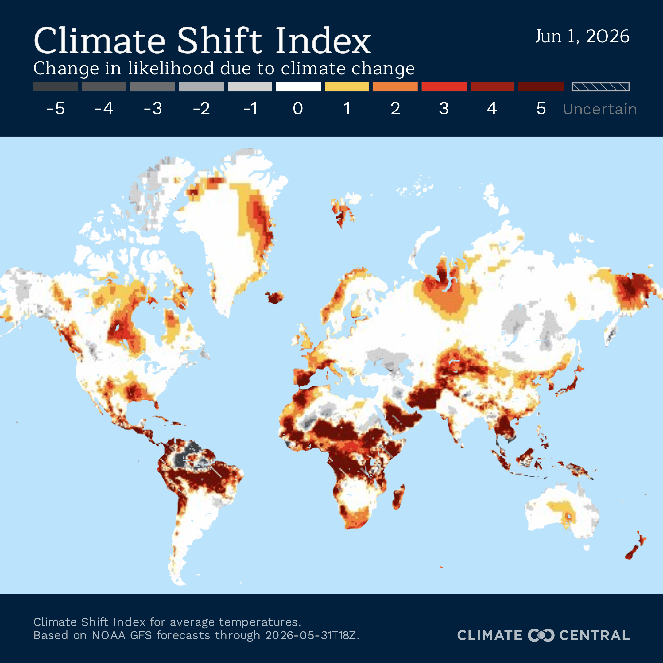
Dust storms, disappearing ice, disrupted fieldwork, flood losses, and changing ocean conditions are shaping climate risks across the areas featured here. In Mali, Mauritania, and Algeria, hotter and drier conditions are helping intensify dust storms that can disrupt transportation, worsen air quality, damage economies, and increase disease risks across the Sahara and Sahel. In Indonesia and Malaysia, climate change is accelerating the loss of Papua’s last tropical glaciers, adding pressure to children’s nutrition, and exposing gaps in flood insurance as disasters become more costly. Farther north, communities and researchers in Svalbard, Norway, and the Faroe Islands are dealing with earlier snowmelt, stronger storms, changing village routines, and ocean temperatures that could complicate aquaculture. Climate Central’s Climate Shift Index1 (CSI) shows unusual heat across these areas this week, alongside climate risks already affecting ice, health, food systems, infrastructure, and local economies in these places.


Need to read this in a language other than English? Try OpenL (up to 1,500 characters) or Google Translate—both offer free translations into 100+ languages.
Mali, Mauritania, Algeria
Climate change is intensifying dust storms and amplifying their impacts across North and West Africa — In late March 2026, an intense dust storm developed over southern Algeria, disrupting trans-Saharan transport routes and choking air quality across North and West Africa. The haboob swept through Mali and Mauritania before extending westward toward the Atlantic, creating a 2,000-kilometer (1,240-mile) “tsunami of dust” that ultimately reached Spain’s Canary Islands. Visible from space, the immense wall of dust engulfed towns and cities across the Sahara, turning skies an eerie orange and reducing visibilities to near-zero. The event underscored the vulnerability of millions of people in Algeria, Mali, and Mauritania to increasingly severe dust storms driven by climate change, land degradation, and desertification. While such storms are a natural feature of arid environments, human-caused climate change is increasing their frequency, intensity, and geographic reach. Rising temperatures accelerate evapotranspiration, drying soils and reducing the vegetation that helps stabilize desert landscapes. At the same time, more frequent and prolonged droughts are leaving vast areas of North Africa and the Sahel exposed to wind erosion. Human land-use pressures are also compounding the risk. Overgrazing, deforestation, unsustainable agricultural practices, and excessive groundwater extraction are accelerating land degradation across Algeria, Mali, and Mauritania. As vegetation cover declines and soils become exposed, powerful winds (often the Harmattan in northern Africa) can lift enormous quantities of sand and dust into the atmosphere, generating storms capable of traveling thousands of kilometers beyond their point of origin.
Home to vast expanses of the Sahara Desert, Algeria is one of the world’s largest sources of atmospheric dust. Dust particles play a crucial role in the Earth’s climate system, acting as aerosols that influence cloud formation, rainfall patterns, atmospheric circulation, and the amount of solar radiation reaching the planet’s surface. Yet climate-driven drought and advancing desertification are leaving increasing quantities of loose sediment exposed, creating ideal conditions for large-scale dust mobilization and the formation of powerful haboobs. Each year, roughly two billion tonnes of sand and dust are lifted into the atmosphere, with more than 80% originating from the deserts of North Africa and the Middle East. In some regions, atmospheric dust concentrations have doubled over the past century, the economic costs of which are often underestimated. Severe dust storms can shut down roads and airports, disrupt trade and supply chains, damage infrastructure and machinery, reduce agricultural productivity, and diminish solar energy output. For countries such as Algeria, Mali, and Mauritania, where transport networks, agriculture, and other climate-sensitive sectors are central to economic development, the consequences can be significant.
As dust storms intensify, disease risks are rising across the Sahara and Sahel — When major dust storms sweep across North and West Africa, they transport more than sand and dust. They can also carry particulate matter and microorganisms that pose significant risks to human health. The massive haboob that formed in southern Algeria in March 2026 before sweeping through Mali and Mauritania has drawn attention to the relationship between dust storms, infectious disease, and climate change. Dust particles account for roughly 40% of aerosols in the lower atmosphere, and their size helps determine how harmful they can be to human health. Larger dust particles can irritate the eyes, nose, and throat, while finer particles (often more than 30 times smaller than the width of a human hair) can penetrate deep into the lungs and even enter the bloodstream. These microscopic particles, known as PM2.5, have been linked to a wide range of health problems, including asthma, pneumonia, stroke, cardiovascular disease, adverse birth outcomes, and premature death. In 2019, long-term exposure to PM2.5 pollution contributed to an estimated 4.14 million deaths worldwide, accounting for approximately 62% of all air pollution-related mortality. That year, more than 19,770 deaths were attributed to PM2.5 exposure in Algeria alone. Globally, the number of deaths linked to ambient PM2.5 increased by about 23% between 2009 and 2019. And now, scientists are increasingly concerned that dust storms also act as biological transport systems, carrying bacteria, fungi, pollen, and other microorganisms across vast distances.
As climate change intensifies drought and desertification across Algeria, Mali, and Mauritania, a growing body of research suggests that expanding dust activity could influence the spread of infectious diseases. One of the clearest examples is meningococcal meningitis. The African Meningitis Belt stretches from Senegal to Ethiopia and encompasses much of the Sahel. Mali lies within this high-risk zone and has experienced recurrent outbreaks of cerebrospinal meningitis (often called spinal meningitis) caused primarily by the bacterium Neisseria meningitidis. Outbreaks typically peak during the dry season, when dusty winds, low humidity, and respiratory infections combine to damage the protective lining of the nose and throat. Studies have repeatedly linked severe dust conditions to meningitis epidemics across the Sahel. Dust-laden air weakens respiratory defenses and may create conditions that contribute to disease transmission. Meningococcal disease remains one of the world’s most dangerous infectious illnesses. If untreated, it can kill within hours, while many survivors experience lifelong disabilities, including hearing loss, neurological damage, and limb amputations. Although large-scale vaccination campaigns, including the introduction of the MenAfriVac vaccine, have dramatically reduced major epidemics, meningitis continues to pose a public health challenge, particularly in remote communities where access to healthcare can be extremely limited.
Dust storms may also facilitate the spread of fungal diseases. Dust clouds can contain enormous numbers of fungal spores capable of traveling thousands of kilometers. In the United States, dust storms have become increasingly associated with Valley Fever, a respiratory disease caused by Coccidioides fungi found in arid soils. Although this pathogen does not occur naturally in Africa, it demonstrates how environmental disturbances can transform dust storms into effective carriers of disease-causing organisms. Scientists are now examining whether changing climatic conditions and increased dust transport could influence the distribution of other fungal pathogens across Africa. One organism drawing particular attention is Cryptococcus neoformans, a fungus commonly found in soil and bird droppings that can cause cryptococcal meningitis, a severe and often fatal infection affecting the brain and spinal cord.

Indonesia, Malaysia
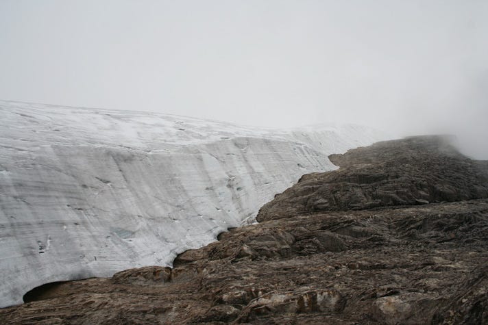
Papua’s last tropical glaciers are close to disappearing as climate change accelerates melting — The remaining glaciers on Puncak Jaya in West Papua, Indonesia, sit above dense rainforest and are known locally as “eternal snow,” but that name is becoming less accurate as the ice rapidly disappears. An expedition to the remote mountain found that the largest remaining glacier has lost about 95% of its area since 2002, leaving only a small remnant of ice where much larger tropical ice sheets once survived. Tropical glaciers are rare, with most found in the Andes and smaller remnants in East Africa and Indonesia, and they are especially vulnerable because they exist near the temperature limits that allow ice to persist. As fossil fuel pollution warms the planet, the remaining ice is melting fast enough that researchers and expedition teams now expect it to vanish within years, not decades. The loss is environmental, but it is also cultural and historical. Their disappearance would remove a feature that has long been part of Papua’s high-mountain landscape. Their local name, “eternal snow,” shows how the ice has been understood as a lasting presence, making its disappearance harder to reduce to a change in glacier area alone. The expedition used drones and satellite positioning systems to build a 3D record of the glaciers before they disappear, partly because cloud cover, heavy rain, steep terrain, and security constraints make the site difficult to study. That record may become one of the last detailed visual archives of ice that survived for thousands of years but is now being erased within a human lifetime.
A 2026 satellite study shows how quickly the ice has disappeared. Papua’s tropical glaciers lost about 97% of their ice cover between 1980 and 2024, shrinking from 7.46 square kilometers to just 0.19 square kilometers. Four of the six glaciers identified in the study have already disappeared, leaving only the Carstensz Glacier and the East Northwall Firn Glacier. The remaining ice is projected to disappear around the end of this decade, with the East Northwall Firn Glacier expected to vanish by 2028–2029 and the Carstensz Glacier by 2029–2030.
Climate change is making it harder to protect children’s nutrition in Indonesia — Children in Indonesia already face high rates of stunting, wasting, poor diets, and food insecurity, and climate change is adding pressure through food, disease, income, and caregiving pathways. Delayed monsoons, drought, flooding, higher temperatures, and extreme weather can reduce rice harvests, damage crops, weaken livestock production, disrupt fisheries, and make nutritious foods harder for families to afford. Those shocks can push households to skip meals, spend a larger share of income on food, or replace fish, meat, fruit, and vegetables with cheaper, less nutritious options. Children are affected quickly because growth, immune function, learning, and long-term health depend on steady access to enough diverse food during early life. Climate change can also increase disease risks that worsen nutrition. Flooding and damaged water systems can raise the risk of diarrhoeal disease, which makes it harder for children to absorb nutrients, while shifting temperature, rainfall, and humidity patterns can affect dengue, malaria, and other infections that drain household resources and weaken health. Higher temperatures also affect adults working outdoors, reducing safe working hours and productivity in ways that cut family income at the same time that children's food and health needs increase.
These pressures can also carry into children’s schooling and development. Children exposed to a climate-linked coral bleaching event were more likely to be severely stunted two years later and more likely to fall behind in school years after the shock. Food, income, disease risk, and caregiving pressures can affect children long after the immediate shock, including their growth, school progress, and long-term health.
Climate change is exposing gaps in Malaysia’s flood insurance system as disasters become more costly and harder to predict — Flooding is already one of Malaysia’s clearest climate-related financial risks, and a 2026 working paper from the Khazanah Research Institute argues that insurance may need to become part of the country’s adaptation strategy, not just a way to pay for damage after disasters. Malaysia’s monsoon patterns and El Niño conditions have become less predictable, while water management problems, rapid development in river catchments, heavier runoff, and reduced river capacity have increased the risk of both surface flooding and river flooding. From 2015 to 2024, reported disaster events and the number of people and families affected by floods rose sharply, putting more strain on national disaster resources. The 2021–2022 floods caused about RM6.1 billion in economic losses, but insurance payouts covered only about RM2.2 billion, or roughly 36% of total losses, leaving the rest to households, businesses, and the government. More than 50 people died and 40,000 people were displaced, losses that are much harder to capture in financial estimates. Flood coverage also remains limited. In 2024, only 17% of surveyed Malaysians reported using flood insurance as a preparedness measure, while 25% reported taking no formal or informal flood preparation steps. Insurers face their own limits because climate risks are changing faster than historical data can capture, local hazard and claims data are often incomplete or hard to access, and many policies run for only 12 months, making coverage vulnerable to yearly premium increases or cancellations after major events. That leaves Malaysia with a difficult problem as floods become more severe. Insurance can provide faster money after disasters and help reduce pressure on public funds, but it will not work well without better local climate and asset data, clearer flood-loss accounting, and public-private risk sharing that keeps coverage affordable for lower-income households and high-risk communities.
Svalbard, Norway, Faroe Islands
In the northern Faroe Islands, stronger storms are becoming a bigger threat to homes, roads, power, and village routines — The Faroe Islands sit in the North Atlantic, where storms are already part of life, but climate change is expected to make the strongest storms more intense and possibly more frequent in this region. A 2024 study focused on the Northern Islands, especially Viðareiði and Hvannasund, where small communities live with steep terrain, rough weather, and limited outside assistance during severe storms. Winter storms can bring extreme winds, with some gusts above 70 metres per second, and the 2016 storm produced the strongest wind speed ever recorded in the Faroe Islands. Past storms have blown roofs off houses, shattered windows, damaged buildings, moved cars, boats, trailers, stones, and containers, cut power, and forced families to shelter in basements or stay with relatives. Storm risk also affects the infrastructure that keeps remote settlements connected. Viðareiði used to be vulnerable to landslides that could cut the village off for weeks before a new tunnel opened in 2016, while Hvannasund and Norðdepil are exposed to strong winds funneled through the sound by the surrounding mountains. Local preparedness has improved because people remember storms in detail and have changed how they protect their homes, including clearing loose objects before storm season, fastening larger items with ropes and old fishing nets, keeping boards or plexiglass ready for windows, and relying on firefighters, neighbors, relatives, and contractors for help.
That local knowledge is part of why people feel able to stay. Families have lived in these villages for generations, houses and land are tied to ancestry, and everyday life is connected to sheep, birds, fishing, the harbor, schools, churches, and neighbors. Warmer, wetter winters and changing wind patterns are also reaching into daily practices. Residents describe less snow, changing wind and precipitation patterns, and conditions that affect traditional practices such as drying mutton. The challenge is that strong attachment to place can help communities prepare and recover, but it can also make future risk easier to underestimate. Many residents feel safe because houses, roads, tunnels, and emergency practices have improved since earlier storms, even as stronger storms may push beyond what past experience can prepare them for.
Svalbard’s unusually early spring is disrupting the fieldwork scientists need to track Arctic climate change — Researchers traveled to Svalbard to measure snowmelt and compare conditions on the ground with satellite observations, but this year the snow disappeared so quickly that some teams could not complete their work. In the Longyearbyen area, April temperatures reached about 4°C instead of the usual -15°C, and bare ground replaced the roughly 30 centimeters of compact snow researchers expected to find. Adventdalen, a valley outside Longyearbyen where Norwegian researchers normally travel by snowmobile, was almost completely snow-free, forcing them to stop fieldwork after only a few days. The University Centre in Svalbard also suspended snowmobile traffic because travel conditions had become too unstable. The early melt disrupted Polish research as well. A team planning to work near the Hornsund research station could not reach its field sites after dense sea ice blocked the fjord and prevented their vessel from unloading people and equipment. At the same time, the west coast of Spitsbergen was already experiencing unusually early and intense snowmelt, stopping planned snow measurements and an isotope experiment on the Werenskioldbreen glacier. For the first time in decades, the Polish team could not carry out fieldwork there at all.
Svalbard is one of the places where warming is happening fastest, with temperatures rising several times faster than the global average, and snow measurements are one way researchers track how those changes are unfolding. Ground measurements help scientists test whether satellite observations accurately capture snow conditions and understand how snow evaporates and melts under warmer conditions. As spring arrives earlier and field conditions become less predictable, researchers may have to start work earlier in the year, rely more heavily on satellites, and find new ways to collect ground data as the snow season becomes shorter and harder to plan around.
Norway’s salmon-heavy aquaculture industry is facing a more complicated future as ocean temperatures change at individual farm sites — Norway is one of the world’s largest aquaculture producers, but Atlantic salmon accounts for about 95% of national production, leaving the industry heavily dependent on one species as marine conditions shift. A 2024 study looked at 34 possible farmed marine species across 12 farm sites in southern, western, northern, and Arctic Norway under three climate scenarios through 2099. Diversifying beyond salmon could give the industry more options as conditions change, but each species has its own temperature limits, and those limits do not line up neatly with Norway’s future ocean conditions. Cold-water species such as witch flounder, spotted wolffish, Norwegian shrimp, snow crab, and red sea cucumber could face more days that are too warm, especially in southern and western Norway and under higher emissions. Warmer-water species farmed elsewhere, including European seabass, gilthead seabream, common sole, John Dory, European plaice, and European abalone, would still face too many cold days at Norwegian sites. Even in southern Norway, cold temperatures would remain challenging for more than half the year for European seabass in the most favorable decade and scenario assessed, and for more than 70% of the year for gilthead seabream, common sole, John Dory, and European plaice.
Temperature risk also changes from site to site and year to year. Nearby farms can have different numbers of difficult temperature days, and individual years can swing enough to affect growth, stress, disease risk, stocking decisions, harvest timing, and the kind of farming system a species would need. Long-term averages are not enough for planning because farmed species have to live through daily and yearly temperature changes, including periods that are too warm, too cold, or stressful when combined with other pressures such as low oxygen, disease, storms, and production-related stress. Some species may grow more slowly in cold conditions, extending the time needed to reach harvest size, while warmer periods can affect behavior, health, immune response, and vulnerability to disease. Moving production onto land, into recirculating systems, or deeper below the surface may help in some cases, but those approaches bring their own biological, technical, energy, cost, and space constraints. New farmed species also take years of research, investment, regulation, market development, and husbandry knowledge before they can be produced reliably. Norway may need a wider set of aquaculture options as the ocean changes, especially because the industry is still built so heavily around salmon. But diversification has to be planned around the range of temperatures farms will actually experience, not just the hope that warming will make new species easier to grow.

We Would Love to Hear From You!
Have you noticed the impacts of climate change in your community? Whether it’s unusual weather patterns or disruptions in local ecosystems, we’d love to hear your thoughts. Share your experiences or observations in the comments below and join the conversation!
Your Feedback Matters
At Global Climate Dispatch, we strive to provide accurate and equitable coverage of climate change and its impacts. If you come across anything that seems inaccurate or concerning, please don’t hesitate to let us know. Your insights help us ensure that the information we share remains truthful, balanced, and relevant to all.
Locations featured are chosen based on data from Climate Central’s Climate Shift Index map. Some graphics used may also come from Climate Central’s Climate Shift Index map. Any original analyses contained in this blog or any views expressed in this blog, unless otherwise noted, are solely the expression of its authors and are unaffiliated with Climate Central or any other entity or person referenced within.
I had to leave my beloved Arizona and moved back to my native Indiana, because of the effects of climate change. Fires, water shortages, dangerous heat…the fact that anyone is still moving to Arizona is beyond crazy.